
")


")
")
")
")
")
What is LiDAR?
LiDAR, which stands for “Light Detection And Ranging”, refers to equipment also known as 3D Laser Scanners. Instead of using conventional cameras, LiDAR sensors emit rapid laser pulses and record the responses, using these data points to map an area with great precision and accuracy. This technology is widely used in various applications, such as topography, mapping, forest monitoring, urban planning and precision agriculture, among others. Its ability to provide precise and detailed data on the shape and elevation of the terrain makes it a valuable tool in various industries.
What is RGB?
RGB refers to the primary colors used in the digital representation of images. An RGB sensor captures different intensities of these three colors to create a color image. Cameras with an RGB color system use sensors corresponding to the wavelengths of the electromagnetic spectrum that can be seen by the human eye. The magnetic spectra that make it up are: R (Red), G (Green) and B (Blue). These cameras are available in various types of devices and equipment. Their ability to capture color information is crucial for various applications, such as mapping, agricultural monitoring, visual inspections, urban planning, among others.
RGB applications
RGB sensors are used for mapping urban areas, agriculture and monitoring vegetation, highlighting visual characteristics. The use of this type of sensor ranges from visual assessment of forest health to visual inspections of infrastructure. RGB cameras obtain quantitative terrain data, making it possible to produce a range of photogrammetric products. RGB technology offers a wide range of applications and is ideal for creating detailed maps, orthophotos and three-dimensional models of geographical areas. These include:
- Point Cloud: A dense point cloud can be generated from drone images. Each point contains geospatial information (X,Y,Z) and colors, providing an accurate model for distances (inclined or horizontal), areas and volumes.
- Orthomosaic: It is possible to determine the topography of the terrain by taking measurements and determining angles, areas, geographic coordinates, distances and perimeters.
- Digital Terrain Model: After removing objects such as buildings and trees, drone images can be used to create digital terrain models, where each pixel contains 2.5D information (X,Y, Z of the highest altitude point).
- Digital Surface Model: Each pixel of the model contains 2D information (X,Y) and the altitude (Z) of the highest point of that position.
- Contour lines: Depending on the requirements of the project, either the MDT or the MDS, using customized curve ranges, can be used to generate contour lines. These provide a better understanding of the surface of the area recorded by the drone, representing constant elevations and demonstrating the topography of the area.
LiDAR applications
LiDAR sensors are highly recommended for a variety of sectors, from topographical surveys to stock volume measurements. Their operation does not depend on ambient light conditions, which allows them to operate effectively on cloudy days, at night or in environments with little or no sunlight. These sensors are mainly used for aerial surveys over large areas of vegetation, where digital photogrammetry can present limitations. LiDAR can efficiently penetrate the empty spaces between branches and leaves, resulting in point clouds that are more faithful to reality. It also uses a lower overlap compared to an RGB sensor, making it possible to map a larger area in less time.
LiDAR technology is widely used in various sectors. In agriculture, it is used to map crops and estimate yields. In the construction sector, it enables the creation of 3D maps that facilitate site planning and the monitoring of construction progress. In addition, LiDAR sensors play a crucial role in civil protection, offering rapid responses to disasters through agile mapping of affected areas and identification of hazards. Their use is not restricted to these areas, but is also of great use in the energy, transportation and urban planning sectors.
DJI LiDAR and RGB solutions
DJI Zenmuse L2: A sensor that integrates a 20 MP RGB camera, 1-inch CMOS and mechanical shutter, as well as an efficient LiDAR system. The L2’s LiDAR system has detection from 250 meters with 10% reflectivity and 100 klx, and up to 450 meters with 50% reflectivity and 0 klx. The L2 sensor not only detects smaller objects in greater detail, but can also penetrate denser vegetation, generating more accurate Digital Elevation Models (DEM).
The mapping camera, with 3.3 μm pixels and 20 MP effective pixels, results in overall image quality, as well as a greater wealth of detail in the point cloud in true color. The mapping camera has a shutter count of up to 200,000 times, further reducing operating costs. When point cloud collection is not required, the RGB camera is still capable of taking photos, recording videos and collecting images for visible light mapping. See the sensor page.
DJI Matrice 350 RTK: A drone with advanced technology that stands out thanks to the integration of a LiDAR system and an RGB camera. This technology is valuable for applications such as surveying, volume measurements and disaster response. The RGB camera, in turn, captures high-resolution color images using the primary colors Red, Green and Blue. The combination of the LiDAR system and the RGB camera on the Matrice 300 RTK offers a complete approach, providing accurate elevation data along with detailed visual information. This makes the drone a versatile tool for diverse applications in sectors such as agriculture, construction, security and much more. See the drone page.
DJI Mavic 3 Enterprise: This drone stands out for its ability to integrate with different payloads, including a thermal camera, a high-resolution RGB camera and a hybrid zoom of up to 56x. The high-resolution RGB camera provides detailed images for visual analysis, mapping and inspections. The hybrid zoom allows essential details to be seen from a distance, making it ideal for firefighting situations, night operations and industrial inspections. In addition, the Mavic 3 Enterprise is designed to withstand adverse conditions, being weatherproof. Its portability, combined with the ability to integrate different payloads, makes it a versatile choice for a variety of sectors, including security, industrial inspections and emergency operations. See the drone page.
YellowScan Solutions
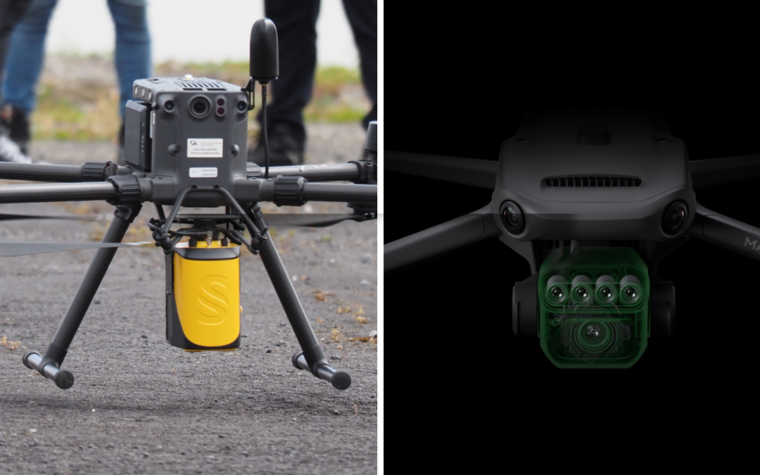
YellowScan Mapper+:The YellowScan Mapper+ can be mounted on a wide range of UAV platforms due to its low weight. It integrates the Livox AVIA laser scanner together with the high-performance GNSS inertial navigation system into a lightweight, autonomous and easy-to-use LiDAR system. Proven capabilities and stable results over a wide range of applications.
Main features:
- Typical flight altitude: 100 m AGL (328 ft)
- System accuracy: 3 cm (1.2″)
- System accuracy: 2.5 cm (1″)
- Battery weight excl.: 983g (2.17lbs)
YellowScan Surveyor Ultra: With its 360° field of view, the YellowScan Surveyor Ultra meets the needs of vertical mapping and mobile mapping when combined with Fly&Drive. Penetration into vegetation is unparalleled thanks to the system’s 32 laser beams.
Main features:
- High stitch density
- Light weight
- 100 m flying height
- Livox AVIA laser scanner
Find out more about YellowScan’s LiDAR sensors or contact an HPDRONES specialist directly.
Final considerations
The choice between a LiDAR and RGB sensor will depend on the nature of the work to be carried out. Drones equipped with RGB sensors will provide detailed images suitable for creating 3D maps, while LiDAR sensors offer greater data accuracy. The selection between them must also take into account inconsistent lighting conditions, in which LiDAR sensors excel. There is no single answer as to which is better, as everything is linked to the specific nature of the mission to be carried out. Our team is on hand to help you find the most suitable solution for your business needs. Get in touch!
_______________________________________________________________________________________________________________________
[ninja_form id=4]
