


")
")
")
")
")
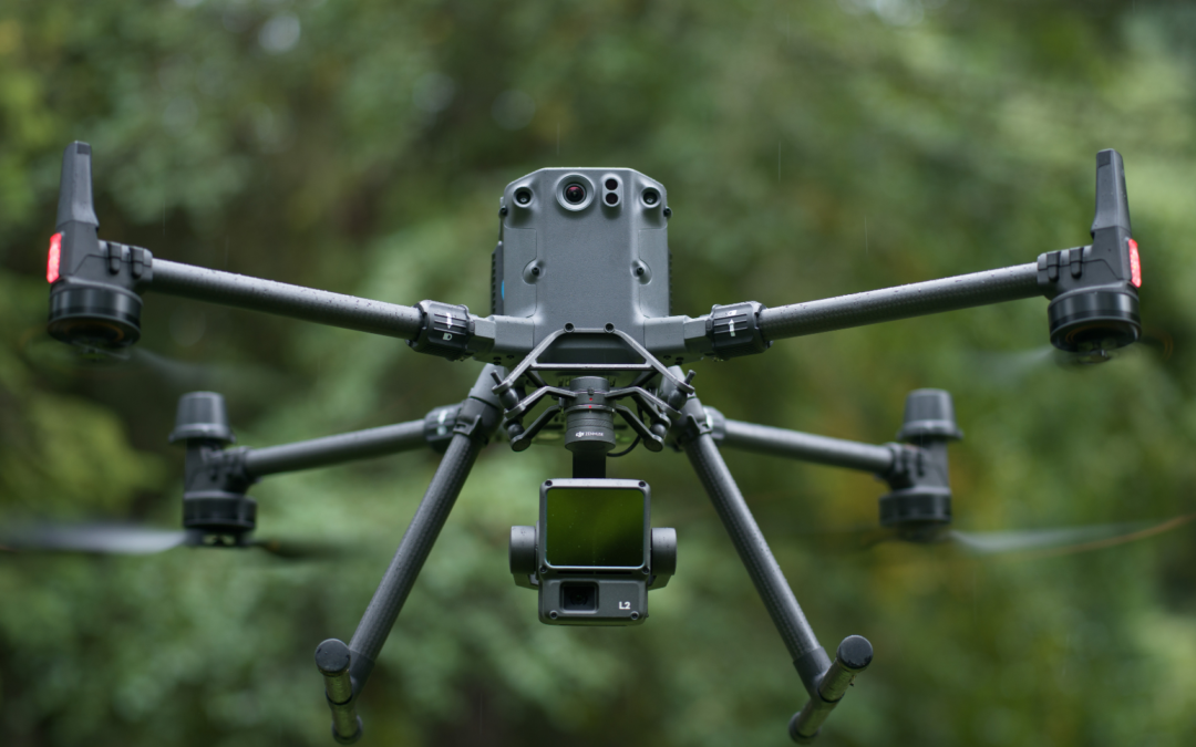
One of the latest sensors launched by DJI, the Zenmuse L2 is a revolution in the field of aerial data acquisition. Designed to meet the specific demands of professionals, the Zenmuse L2 stands out for its advanced features that make it an indispensable tool in many fields. Together with the Matrice 350 RTK it brings exceptional performance in data collection. Discover the main features that make this sensor the right choice for businesses.
One of the latest sensors launched by DJI, the Zenmuse L2, brings a revolution to the field of aerial data acquisition. Designed to meet the specific demands of professionals, the Zenmuse L2 stands out for its advanced features that make it an indispensable tool in many areas. Together with the Matrice 350 RTK, it brings outstanding performance in data collection. Discover the main features that make this sensor the right choice for companies.
Advanced GNSS and IMU integration
Organizations are increasingly committed to improving data collection techniques in order to improve the efficiency of work processes. The Zenmuse L2 sensor stands out for its exceptional accuracy, due to the integration of the high-precision satellite navigation system (GNSS) and DJI’s customized inertial measurement unit (IMU). The IMU’s accuracy has been optimized to 0.05° (real time) and 0.025° (post-processing). This guarantees both vertical and horizontal accuracy, resulting in excellent geospatial data for various applications.
Multi-functional in various industries
The L2 sensor is adaptable and can be used in various areas, from surveying and construction to agriculture and environmental monitoring. The ability to meet different demands, such as live display of the point cloud, one-click processing in DJI Terra, various types of routes, among others, makes this sensor a vital piece of equipment. Its resistance to weather conditions and challenging terrain makes it ideal for professionals operating in diverse and demanding locations.
Live streaming
In emergencies it is essential to have fast and essential responses. The sensor has real-time data transmission capabilities and offers instant access to crucial information. During operation, the DJI Pilot 2 app supports three display modes – in RGB, point cloud and point cloud/RGB side-by-side display, delivering operational results intuitively.
Software DJI Terra
The combination of Zenmuse L2, Matrice 350 RTK and DJI Terra transforms the efficiency of information processing. With just one click, DJI Terra processes intricate data, offering a complete solution for capturing and analyzing precise 3D data. The user can also preview, play back and process on-site point cloud models generated by DJI Terra.
Unrivaled efficiency
The Zenmuse L2 stands out for its incredible operational efficiency, being able to cover large areas quickly while maintaining data quality. This unique combination of speed and precision makes it essential for projects that require efficient and accurate data collection. Just plug it in and it’s ready to go, capable of collecting geospatial and RGB data from an area of 2.5 km2 in a single flight.
Unparalleled details
With high-resolution image capture, the sensor reveals subtle details that escape the naked eye. An essential capability in sectors such as heritage conservation, geological surveys and precision engineering. The mapping camera has a shutter that supports up to 200,000 actuations, which reduces operating costs. When point cloud collection is not required, you can use the RGB camera to photograph, film and capture images for mapping using visible light.
Security and detection
Advanced safety features are available, such as automatic return in situations of signal loss and real-time alerts, ensuring safe operations in all circumstances. The Zenmuse L2 sets new standards by being compatible with long-range drones with remarkable endurance. These features make it the ideal choice for extensive missions in remote locations, or for projects that demand wide coverage and consistent operations.
Excellent range
The L2 laser detection system has a detection capacity of between 250 and 450 meters, depending on the reflectivity of the target and the lighting conditions. The typical operating altitude has been extended to 120 meters, providing notable improvements in safety and efficiency. It is important to note that this data may vary depending on the terrain, the type of target and the nature of the mission. These improvements make the Zenmuse L2 ideal for large-scale mapping, providing detailed data even in challenging conditions.
In this way, substantial improvements in the performance of the L2 LiDAR have been achieved, bringing a significant reduction in the size of the L1 points, especially when the object or area is at a distance of 100 meters from the LiDAR. The penetration capacity has been optimized, extending both the detection range and the accuracy of the system. The RGB camera showed a notable increase in pixel dimensions compared to the L1. The accuracy of the Inertial Measurement Unit (IMU) was also optimized, as already mentioned in this article. It is worth noting that the LiDAR is now compatible with the Telemetric Sensor (RNG), demonstrating a technologically advanced and efficient solution. The combined improvements bring greater precision and performance in applications that rely on these technologies for detection and measurement.
Contact our sales department for more details on this revolutionary tool and to find out how you can apply it and improve results within your organization.
______________________________________________________________________________________________________
|
|
