
")


")
")
")
")
")
The world of geospatial technology is undergoing an unprecedented transformation. The ability to digitize the physical world with precision, speed, and photorealism is redefining entire industries. In this innovative landscape, HPDRONES is proud to announce a strategic partnership that promises to shape the future of reality capture in the Iberian Peninsula: we are now the official distributor of XGRIDS for Portugal and Spain.
This collaboration combines the extensive experience and localized support of HPDRONES, a benchmark with almost two decades of activity in the Iberian market, with the cutting-edge technology of XGRIDS, a world leader in SLAM (Simultaneous Localization and Mapping)-based 3D scanners and revolutionary 3D Gaussian Splatting technology. The goal is clear: to bring advanced 3D scanning and LiDAR SLAM technology to our market, enabling companies to transform physical reality into high-precision digital models with unprecedented ease and speed.
What does this partnership mean for professionals?
For professionals in a wide range of sectors, from construction and surveying to film production and real estate, this partnership is not just a novelty, but a catalyst for efficiency and innovation. The combination of XGRIDS technology and HPDRONES expertise offers a complete ecosystem that goes far beyond simply selling equipment.
Optimized workflows and specialized assistance
The major advantage of this partnership lies in the creation of seamlessly integrated digitization workflows. XGRIDS and HPDRONES collaborate to shorten the path from data capture to final delivery, ensuring smoother implementation and more reliable 3D results. HPDRONES brings its practical field knowledge, specialized training, and operational support to the table, helping teams implement the new workflows with complete confidence.
Unmatched operational efficiency
XGRIDS technology has been designed to be radically more efficient than traditional methods. A notable example is the ability to digitize a multi-story property measuring approximately 300 square feet in just 15 to 20 minutes, a task that could take 3 to 4 hours with a tripod and a 360° camera. This dramatic acceleration allows projects to move forward more quickly, reducing costs and eliminating the need for multiple site visits.
Direct access to the technology of the future
The association provides Iberian professionals with the tools that are defining the next generation of 3D content. Technologies such as 3D Gaussian Splatting (3DGS) and Multi-SLAM are no longer distant concepts, but practical and accessible solutions for creating photorealistic digital twins, immersive environments for VR/AR, and high-precision models for engineering and analysis.
XGRIDS technology: an in-depth analysis
- 3D Gaussian Splatting (3DGS): The end of flat images
3DGS is an innovative technology that represents a quantum leap forward from traditional 3D capture methods. Instead of creating polygonal meshes or static point clouds, 3DGS uses a collection of Gaussian “splats,” 3D particles with color, opacity, and shape, to reconstruct a scene. The result is XGRIDS technology: an in-depth analysis of photorealistic 3D models that can be explored in real time, with realistic lighting and perspectives, as if we were walking through real space. This technology transforms any location into interactive spatial models that can be navigated, edited, and shared, representing the future of content creation.
- SLAM (Simultaneous Localization and Mapping): freedom of movement
SLAM technology is what makes XGRIDS scanners portable and usable on the move. As the user walks, the scanner uses its sensors (LiDAR, cameras, IMU) to simultaneously map the environment and determine its own position within that map. This eliminates the need for tripods and static positioning, allowing for continuous and rapid data capture, both indoors and outdoors.
- LCC (Lixel CyberColor): The intelligent software ecosystem
Hardware is only half of the equation. LCC Studio software is the brain behind the operation, processing the raw data captured by the scanners to generate the final 3D models. LCC combines 3DGS with Multi-SLAM algorithms to create lightweight, measurable, photorealistic spatial models, ready to share on any platform, from a web browser to virtual reality glasses.
The XGRIDS product range at HPDRONES
HPDRONES offers a complete range of XGRIDS solutions, each designed for specific needs, but all with the same DNA of innovation and ease of use.
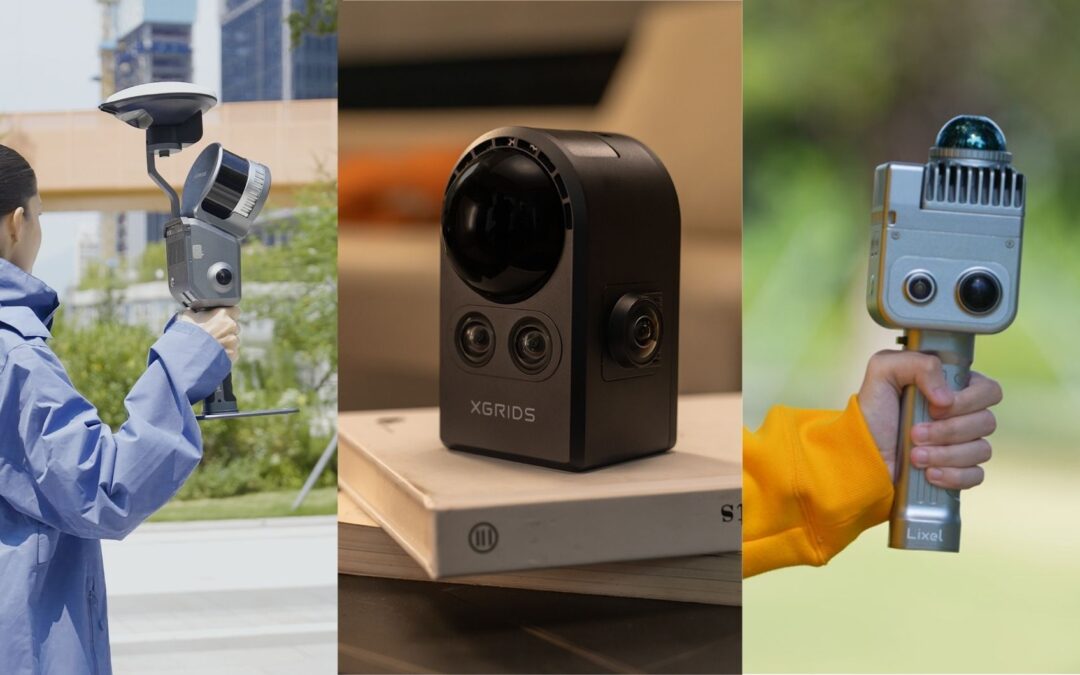
XGRIDS PortalCam: the first authentic space camera
PortalCam is undoubtedly XGRIDS’ flagship product and represents a new category of devices. It is not a camera or a camcorder; it is a “spatial camera” that captures entire locations as photorealistic 3D worlds.
How does PortalCam work?
The magic of PortalCam lies in the fusion of multiple sensors and patented algorithms:
- Perfect spatial structure: advanced detection, combining LiDAR and computer vision, ensures accurate spatial relationships, from intimate interiors to wide street views.
- Complete visual coverage: two fisheye cameras capture every angle, while two front cameras preserve the smallest details, allowing you to even read text on the generated 3D models.
- Advanced spatial computing: proprietary algorithms and integrated processing merge data from all sensors into spatial models that adapt without losing detail, ensuring impressive visual quality.
The 3-step process for spatial content
XGRIDS has simplified the creation of 3D content in an intuitive workflow:
- Capture: Simply walk naturally while PortalCam records. The process can be monitored via the LCC Scan application.
- Process: LCC Studio software automatically generates Gaussian Splatting 3D models from captured data, with minimal manual intervention.
- Apply: The generated LCC models are lightweight and can be easily edited, shared via a simple link, and integrated into existing workflows, such as Unreal Engine, Unity, and web platforms.
PortalCam Applications
- Real estate agencies: Create virtual tours where buyers can freely navigate through each room, with accurate lighting and measurements. Digitize a property in minutes and share it instantly, helping you close deals faster.
- Film production: Scout locations remotely, test lighting setups and camera movements in virtual environments. The models are perfect for virtual production on LED screens and green screens, drastically reducing production costs.
- Content creation: The creation of 3D worlds has been democratized. Now anyone can digitize a real place and turn it into a reusable asset for games, immersive experiences, and digital narratives.
- Personal memory: immortalize important moments, not as flat photos, but as spaces your family can revisit. Preserve the complete spatial context of an event, from the decor to the atmosphere, for future generations.
XGRIDS Lixel K1: the compact and powerful 3D scanner
For professionals who need a fast, portable, and accurate 3D scanning solution, the XGRIDS Lixel K1 is the ideal tool. Weighing less than 1 kg, this portable scanner is designed for anyone to use: “Pick it up, walk, and scan.”
The Lixel K1 generates highly detailed, full-color 3D models with unmatched ease and speed, transforming days of tripod work into just a few hours of motion capture.
Key features of the Lixel K1:
- Lightweight and portable: weighing less than 1 kg, it allows for effortless operation without the need for tripods or heavy equipment.
- Professional results: offers ±1.2 cm accuracy, capturing reliable data for interior documentation, topographic surveys, and BIM integration.
- Fast capture: its 360° LiDAR system captures 200,000 points per second, while 48 MP panoramic cameras ensure rich, realistic color 3D models.
- Real-time operation: color models are generated in real time, eliminating post-processing delays and enabling immediate on-site decisions.
Technical specifications of the Lixel K1
XGRIDS Lixel L2 Pro: professional accuracy for large-scale mapping
When scale and precision are paramount, the XGRIDS Lixel L2 Pro comes into play. It is a state-of-the-art 3D scanner, specifically designed for large-area mapping applications, both indoors and outdoors.
One of its most distinctive features is its versatility. In addition to manual operation, the L2 Pro can be mounted on drones, such as the DJI M350 RTK, to perform aerial mapping with SLAM technology. This capability allows it to capture LiDAR data with true colors and centimeter-level accuracy, combining the agility of a drone with the power of SLAM to efficiently cover vast or complex terrain.
Key features of the Lixel L2 Pro:
- High point density: capable of generating up to 1 million points per square meter, offering exceptional detail.
- Absolute accuracy: with an absolute accuracy of just 3 cm, it is the ideal tool for surveying, infrastructure, and construction surveys.
- Multi-SLAM Algorithms: Ensures reliable data capture even in the most challenging environments, with deep optimization through AI.
- Air and ground flexibility: The ability to mount it on drones opens up new frontiers for mobile mapping, allowing the fusion of aerial and ground data to create complete and cohesive 3D models.
Transforming industries in the Iberian Peninsula
The XGRIDS product range, now available through HPDRONES, is poised to drive innovation in multiple key sectors of the Iberian market.
- Construction and architecture (AEC)
The ability to create detailed “as-built” documentation in minutes, monitor construction progress with pinpoint accuracy, and integrate models directly into BIM workflows represents a huge improvement in efficiency. Reduced site visits and clear data improve communication between all stakeholders.
- Real State
Immersive virtual tours created with PortalCam offer a viewing experience far superior to 360° videos or photos. Potential buyers can explore a property at their own pace, from any device, which increases their confidence and speeds up purchasing decisions.
- Content production, film, and video games
The Iberian Peninsula, with its unique locations, is a privileged setting for audiovisual production. XGRIDS technology allows filmmakers and video game creators to digitize real locations for previewing, virtual production, or as digital assets for their projects, democratizing the creation of realistic 3D worlds.
- Surveying, Energy, and Infrastructure
With Lixel L2 Pro, both in terrestrial and aerial modes, large-scale mapping projects for surveying, power line inspection, or infrastructure management become faster and safer. HPDRONES, with its expertise in these sectors, is perfectly positioned to help companies integrate these new capabilities.
The future is now
The partnership between HPDRONES and XGRIDS is more than just a distribution agreement; it is a commitment to the future of 3D digitization in the Iberian Peninsula. By combining the world’s most advanced spatial capture technology with nearly two decades of local experience, technical support, and training, we are creating an unmatched value proposition.
We are training professionals to work smarter, faster, and with a level of detail and realism that was previously unthinkable. The future of reality capture is not coming—with HPDRONES and XGRIDS, it is already here.
Ready to revolutionize your workflow?
Discover how XGRIDS technology can transform your business. Our team of experts is ready to help you find the perfect solution for your needs.
Get in touch with HPDRONES today!
_________________________________________________
