
")


")
")
")
")
")
UgCS
Drone flight planning and control software by SPH Engineering
SPH Engineering is the expert in drone technology development, with a decade of experience in creating advanced UAV solutions. They have a strong global presence, with a customer base and partner network in more than 150 countries.
Automated drone mission planning, integrated photogrammetry and geotagging tools, import of digital elevation models (DEM) and KML files allows map customization, and the battery switching option for long routes make UgCS an effective solution for large area surveying.


Automated LiDAR toolset
Field monitoring
Importing routes from KML or CSV files
Photogrammetry tool.
Vertical scanning tool
Area scan tool for non-camera sensors
Corridor mapping, SAR patterns
Import of custom maps and custom data
Live geotagged video streaming
Offline work
UgCS main benefits

Save time and money
- UgCS is universal and supports most commercially available drones.
- Import and create routes from customer-supplied KML data and save more than 50% of your time.
- Save travel days and before leaving the site, validate acquired data by merging images with UgCS Mapper offline processing software.
Increased flight safety
- Increase data capture productivity by at least 2x with the built-in automatic photogrammetric planning tool.
- Plan and fly missions offline, even in desert areas, thanks to the offline map caching feature.
- Fly long routes, resuming flights from a given waypoint after battery change
Increase surveying productivity
- Use pre-installed DEM data or import more accurate DEM data to increase the accuracy and safety of terrain-tracking missions.
- Adjust the permitted flight range and no-fly zones to fly in accordance with regulatory requirements.
UgCS main benefits
Save time and money
- UgCS is universal and supports most commercially available drones.
- Import and create routes from customer-supplied KML data and save more than 50% of your time.
- Save travel days and before leaving the site, validate acquired data by merging images with UgCS Mapper offline processing software.
Increased flight safety
- Increase data capture productivity by at least 2x with the built-in automatic photogrammetric planning tool.
- Plan and fly missions offline, even in desert areas, thanks to the offline map caching feature.
- Fly long routes, resuming flights from a given waypoint after battery change
Increase surveying productivity
- Use pre-installed DEM data or import more accurate DEM data to increase the accuracy and safety of terrain-tracking missions.
- Adjust the permitted flight range and no-fly zones to fly in accordance with regulatory requirements.
Compatible drones and autopilots
DJI
| M30 SERIES |
| MAVIC 3 ENTERPRISE SERIES |
| M600 |
| M200 / M210 SERIES |
| M100 |
| INPIRE SERIES |
| PHANTOM 4 SERIES |
| MAVIC 2 SERIES |
AUTEL
| EVO II SERIES |
FREEFLY
| ALTA X |
WATTS INNOVATIONS
| PRISM |
INSPIRED FLIGHT
| IF1200 |
MAVLINK COMPATIBLE
| ARDUPILOT/PX4 MULTICOPTER/HELICOPTER |
| APM AIR LANE |
OTHERS
| VTOLS / FIXED WING |
Create routes from KML
KML files with survey area boundaries can be imported into UgCS to define the precise location of the survey.
- LineString segments from the KML file will be imported as a single Waypoint route.
- The LinearRing segment can be imported as a route type “Area scan”, “Photogrammetry” or “Perimeter”.
PLAN SURVEYS WITH TERRAIN FOLLOWING
Mission planning in terrain-following mode allowing a very low flying vehicle to automatically maintain a relatively constant altitude above ground level.
The accuracy of the default UgCS SRTM database varies, therefore to enable accurate and safe flight altitude, accurate DEM (Digital Elevation Model) data must be imported from the survey area.

Import DEM for safer mission planning
The terrain is always changing, but the changes are not always implemented on 3D maps as quickly as needed. To plan an automated low-altitude or terrain-following mission for mapping, surveying or monitoring purposes, import the Digital Elevation Model (DEM) to UgCS for safe mission planning.
Importación de imágenes georreferenciadas como superposiciones de mapas
To fly automated drone missions accurate maps are more important than ever. Import GeoTIFF images as a map overlay in UgCS, providing the power to customize maps to meet your needs.
Mission planner | Drone control
Immersive 3D mission planning environment
To plan an automated low-altitude or terrain-following mission for mapping, surveying or monitoring purposes, import the Digital Elevation Model (DEM) to UgCS for safe mission planning.
Drone survey planning tools
Choose one of the pre-installed camera profiles or create a new one to suit your camera. LiDAR, Photogrammetry, Corridor Mapping, Vertical and Area Scanning will calculate the flight path based on the drone configuration.
Facade scanning tool
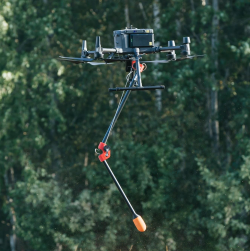
The vertical scan tool allows you to plan a vertical plane, specify the distance to the wall, the lateral and frontal overlap. Supports import of 3D objects and DEM data with terrain tracking function. Useful in mining to examine open quarries.
Elevation Profile
Once UgCS completes the flight path calculation, the path elevation profile displays the AGL and AMSL altitude of the drone. Accurate altitudes above sea level at all points provide the ability to plan drone missions with respect to the surroundings.
Telemetry window
The telemetry data window in UgCS displays telemetry data including battery charge level, radio link and GPS signal quality, current course and heading, speed, altitude and much more.
Automatic flight mode (waypoints) and direct control of the drone
Allows multiple flight modes. The manual flight mode allows you to control the drone with the remote control. Once a flight plan is created and uploaded to the autopilot the Auto flight mode can be used.
Software emulator
There are integrated software emulators for quadcopters and fixed-wing drones: emucopter and emuplane. Allows you to test a route before uploading it to a real drone. Feel free to test various UgCS features and configurations in a secure environment.
UgCS LICENSING
One-time purchase. Includes the first year’s support package and annual update.

UgCS PRO PERPETAL
The UgCS PRO license is designed with professional drone pilots and service providers in mind. It features all the main UgCS features listed below with the exception of LiDAR flight planning tools (available in UgCS EXPERT) and video streaming & multi-node deployment (available in UgCS ENTERPRISE).
More information

UgCS EXPERT PERPETUAL
The UgCS EXPERT license is designed for professional drone pilots flying with LiDAR sensors. It comes with all the features of UgCS PRO as well as the new LiDAR survey toolset. Discover why UgCS EXPERT is the best choice for professional drone pilots and LiDAR surveyors around the world.
More information

UgCS ENTERPRISE PERPETUAL
It is designed for deployment in small and large-scale companies that employ drone pilots for various purposes such as infrastructure surveillance, security, law enforcement, aerial video monitoring, LiDAR data collection and other purposes. It is also used by professional drone pilots and search and rescue (SAR) teams that require streaming video.
More information
UgCS Commander
- Simultaneously control multiple drones to save time and resources with coordinated drone flights.
- Compatible with DJI and other leading drone manufacturers, seamlessly integrating drones from different brands into a single platform.
- Real-time telemetry panel, allowing you to monitor critical drone data at a glance 3D environment for drone monitoring, allowing you to visualize drone operations in real time.
- Customizable flight control, allowing you to adapt the drone’s missions on the fly.

UgCS Mapper
- Photogrammetric processing to convert drone images into accurate 2D maps and 3D models for precise surveying and construction measurements.
- Compatibility with various drone models to offer flexibility and usability for users with different drones.
- Cost-effective solution to provide an affordable mapping and modeling tool, lowering the barrier to entry for small businesses and professionals.
- Generation of orthomosaics to produce high-resolution, high-resolution and georeferenced maps for analysis in sectors such as agriculture, urban planning, environmental monitoring, education and others.

Airborne sensors for advanced data acquisition
- Photogrammetric processing to convert drone images into accurate 2D maps and 3D models for precise surveying and construction measurements.
- Compatibility with various drone models to offer flexibility and usability for users with different drones.
- Cost-effective solution to provide an affordable mapping and modeling tool, lowering the barrier to entry for small businesses and professionals.
- Generation of orthomosaics to produce high-resolution, high-resolution and georeferenced maps for analysis in sectors such as agriculture, urban planning, environmental monitoring, education and others.
SkyPort
Echo Sounder
Ground Penetrating Radar
Methane Detector
Magnetometer
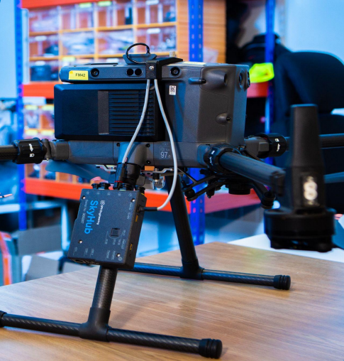
SkyHub
An on-board computer designed to enhance the capabilities of commercial UAVs for industrial purposes to record geotagged data from various sensors and collect and store data acquired by an UAV. geotagged from various sensors and to collect and store data acquired by an on-board sensor with altitude radar.
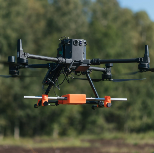
Ground Penetrating Radar
A geophysical technique that uses radar pulses to image the subsurface of the ground.
APPLICATIONS
– Search for small objects (high frequency GPR).
– Glaciology, snow/ice thickness profiling
– Geological stratigraphy and geotechnical studies
– Archeology
– Forensic investigation
– Utility and subway infrastructure mapping
– Freshwater bathymetry
– Mining and quarrying
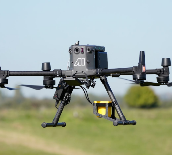
Methane detector
– Mining and quarryingA methane detector is used to detect the presence of methane gas in the air to monitor gas leaks in industrial, commercial and residential environments.
APPLICATIONS
– Dairy industry
– Landfill industry
– Air quality compliance by environmental consulting companies
– Leak detection and repair service companies
– Drone service providers
– Oil and gas suppliers
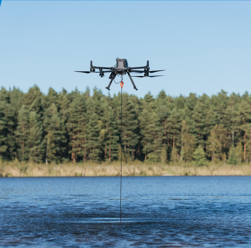
Echo sounder
A type of sonar device used to measure water depth and detect underwater objects.
APPLICATIONS
– Mapping of water and sediment depths prior to dredging and cleaning in shallow or algal ponds, lakes, rivers and canals.
– River and lake bottom profiling for scientific research and environmental monitoring.
– Flood inundation mapping.
– Underwater inspections for engineering works (bridge crossings or pipelines)
pipelines).
– Mapping of oxidation and tailings pond sediments.
– Sludge volume measurements in waste stabilization ponds.
Magnetometer
A magnetometer is a passive sensor that measures magnetic density. Determines the direction, intensity or relative variation of the magnetic field.
APPLICATIONS
– Search for UXO (unexploded ordnance).
– Location of buried infrastructures (metallic pipes and shielded cables)
Archeology.
– Prospecting for any metallic object weighing a few hundred grams or heavier underground.
– Prospecting for regional variations in the magnetic field for mineral exploration.
Other technologies and products:
Drone Show Technologies:
– Create drone shows for any location.
UgCS SDK
● SDK for third-party drone software developers implementing: In-flight drone control.
● Flight planning tools.
● Telemetry transmission/recording.
● Streaming/video recording.
● UTM integration.
● Integration into the drone dock.
DroneGIS Platform
– A data management platform for the drone department to store, visualize and share imagery, orthophotos, DSM/DTM and DXF point clouds. DroneGIS streamlines: Access to survey data via web interface

FREQUENT QUESTIONS
Is an Internet connection required to use UgCS?
UgCS provides the ability to cache maps and elevation for offline use. Thus, only an Internet connection is required for the first activation of the license and the caching of the maps of the selected regions. After that you can use UgCS in the most remote regions of the Earth without the need to connect to the internet – with the drone using only the local network (which can be configured using a router or a contemporary mobile device as a hotspot).
How do I connect my drone to UgCS?
To connect DJI drones to UgCS you need to have the UgCS mobile app for DJI installed either on an Android mobile device or on the DJI Smart Controller. The device then needs to be connected to the same local network (no internet required) as the computer with UgCS installed and the drone will automatically appear in UgCS.
To connect other supported drones such as Ardu / PX4 – a connection is established via radio telemetry link (with the ground radio connected to the computer via USB) or WiFi (no internet connection required).
Do I need an Android device to fly a DJI drone with UgCS?
To connect a DJI drone to UgCS you will need either an Android mobile device connected to the DJI Remote Controller (RC) via USB or to the DJI Smart Controller.
How can I install UgCS for DJI on the DJI Smart Controller?
The first step is to download the UgCS .apk file for the DJI mobile application using the Direct Download option from ugcs.com/dji.
Then save the .apk file to the Smart Controller, open it with the file browser application and install it.
Does UgCS support LiDAR IMU calibration?
Yes. UgCS EXPERT and UgCS ENTERPRISE licenses provide access to figure-eight and U-shape/J-hook calibration standards.
Can I fly vertical scan missions with UgCS?
Yes! UgCS gives you access to the Vertical Scan tool, allowing you to perform vertical drone inspections of buildings, communication towers and other objects. The Vertical Scan tool is included in all UgCS license types.
Can I fly a route created in UgCS in DJI Pilot?
Yes! Routes from UgCS can be exported as KML format files and then imported and used in DJI Pilot/Pilot2.
