
")


")
")
")
")
")
The world’s highest peak, Mount Everest, is the destination of countless climbers. Some 6,664 people have climbed Everest and, according to the data, each climber leaves behind an average of 8 kg of garbage. For a smoother ascent and a safer return, climbers rarely bring their garbage back, leaving it all on the slopes of Everest. The challenge of descending this garbage is monumental, especially in the Kumbu Ice Fall region, known for being dangerous and unstable, where local Sherpas risk their lives on a daily basis.
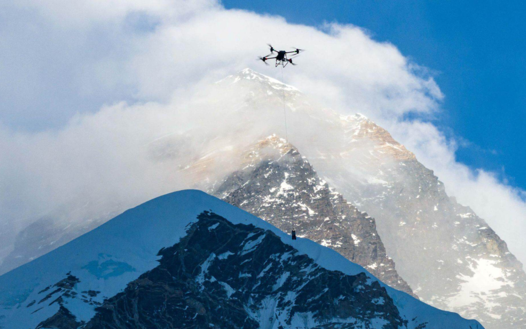
In an effort to address these challenges, DJI Delivery, in collaboration with the company 8KRAW and with local support from Nepal, conducted the first delivery test using drones on Everest. This technological breakthrough represents a potential revolution in the sector, aimed at minimizing risks during the crossing of the Kumbu Ice Fall.
Members of the mountaineering team stressed the crucial importance of drones in reducing the dangers faced on Everest. Through the use of drones, it was possible to transport 15 kg of waste from one camp to another, not only contributing to the clean-up of Everest, but also to the protection of the lives of millions of people living in the Himalayas. This is not only a technological milestone, but also exemplifies the commitment to using innovation to improve safety and protect the environment of Everest and its surroundings.
Between April 25 and May 1, DJI Delivery, with the FlyCart30 drone, carried out hover tests, unladen transport tests and laden round-trip transport tests in the southern base camp region, at an altitude of 5,300 meters and at higher altitudes. The FC30 proved to be stable when transporting a 15 kg payload of supplies to Base Camp 1, located at an altitude of 6,000 meters. Compared to conventional methods, which would require 6 to 8 hours of walking, the FC30 completed the task in a remarkable 10 minutes, demonstrating a significant reduction in the time required.
Strong signal
During preparations, the DJI team discovered that parts of the route between Base Camp and Camp 1 interfered with the drone’s visibility. After conducting a search and repositioning the launch point to avoid the obstructions caused by the mountain, they found a location with less signal interference. As with other drones, loss of signal means loss of connection with the remote control.
However, by planning a flight path that continues even after signal loss and using a cable with a self-releasing mechanism, it was possible to transport cargo to Field 1. This problem could easily be solved using the dual operating mode, in which a second control is repositioned along the route. But for these tests, this implied an experienced pilot climbing on foot to Camp 1, which requires a climbing license, so this approach was not adopted during the first delivery tests.
After an inspection of the camp, it turned out that the terrain from Camp 1 to the Khumbu Icefall is relatively flat, allowing passers-by to make round trips quickly. With the help of the DJI Mavic 3T, it was possible to identify a stable target point for single-control flights in Camp 1, effectively solving the signal and control problem.
Final considerations
After the tests, it was confirmed that the DJI Flycart 30 was able to take off and remain stable even in weather conditions of -5 °C, withstanding winds of up to 15 m/s and operating at an altitude of 5300 meters. The drone reached a maximum altitude of 6,191.88 meters and was able to hover for 17 minutes, covering a distance of 2.7 km with a payload of 15 kg. After completing the round trip, the Flycart 30 still had 43% battery left.
These results set a new world record for low-altitude transportation and open up new possibilities. The Flycart 30’s performance on Everest has received significant recognition from local authorities and organizations and is expected to bring new solutions to various commercial mountaineering projects around the world. The use of commercial transport ushers in a new era for high-altitude mountaineering and rescue operations.
____________________________________________________________________________________________________
