
")


")
")
")
")
")
PIX4D
A unique photogrammetry software package for mobile and drone mapping
Produce survey results such as maps and 3D models from drone imagery.
Increased productivity – Increase the efficiency of your surveys through drone mapping and save operating costs by reducing time in the field.
Accurate results – Ensure accuracy with our quality reports, convenient and detailed editing tools, ground control points, control points, and RTK drone support.
Always up-to-date maps and terrain models – Thanks to a simple workflow and easy repetition of data capture, maps and models can be updated as often as needed.
Simplified inspections – capture images and data easily with your mobile device and the PIX4Dcatch rover or viDoc RTK, a drone or automatically with our CraneCamera solution. Create accurate 2D maps and 3D models, instantly upload them to the cloud and view them anywhere in the world.
Save time and costs – get results faster than ever before. Pix4D solutions for construction cost nothing compared to traditional measurement methods, with the same high accuracy you can rely on.
Greater control of performance – your data is available faster and can be shared immediately with project stakeholders anywhere in the world for improved communication and collaboration.
Agricultural management – Analyse crops with vegetation indices. Create and implement prescription treatment plans. Optimise yields with precision farming.
Research and development – Planning and plotting test plots. Obtaining accurate results from crop information. Remote sensing and image analysis for better results
Security – Obtain comprehensive analysis in the field. Identify and quantify damaged or affected crops. Create and share reports on claims or findings.
Integrated agricultural platforms – Integrate Pix4D algorithms with your own platform. Provide high quality agricultural analysis services Automate and integrate your own businesses.
Faster data collection – work faster in the field by reducing data collection time with automated flight plans.
Automated asset inventory – get an automatic record of tower assets thanks to AI-powered algorithms that start the work for you.
Reduce inspection time – reduce time spent inspecting assets with integrated tools that streamline your workflow.
Accidental Drone Reconstruction – Unmatched accuracy when recreating scenes in 3D. Work with imperfect imagery and adapt to the data collected. Create true models for reliable investigations.
Terrestrial scene reconstruction – Portable RTK rover connected to mobile devices. Rapid data collection with mobile scanning. Real-time 3D results to verify scene completion.
Emergency response – Rapid 2D mapping for firefighting, disaster response or search and rescue. Rapid deployment and shareable GeoTIFF results. Free sharing via cloud service.
Supply chain management – streamline your supply chain with accurate, automated inventory volume calculations.
Asset lifecycle management – gain an overview of your assets at every stage of their lifecycle.
Simplify visual inspections – Pix4D’s intelligent inspection tools speed up your work and reduce the number of images you need to inspect, automatically extracting critical information.
Automatic reporting – get all the information about your inspections thanks to automatically generated reports containing all your notes. Save time and money on report writing.


PIX4DMATIC
State-of-the-art photogrammetry software for professional terrestrial and drone mapping
- Larger datasets, accurate results: PIX4Dmatic processes thousands of images while maintaining topographic accuracy. By eliminating the splitting and merging stage, it cuts the time it takes to create point clouds from images in half.
-
Simplified processing: The software was developed in close collaboration with prospectors and mapping professionals with the aim of streamlining their workflow. Import, process, and evaluate the quality of a project in just a few clicks, and navigate seamlessly from PIX4Dmatic to PIX4Dsurvey.
-
Integrated workflow: Take advantage of photogrammetry and LiDAR technology. Process LiDAR and RGB images from PIX4Dcatch for a complete terrestrial workflow. Easy and desktop-based.

PIX4DSURVEY
The meeting point between photogrammetry and CAD.
- Vectorize without limits: Harness the combined potential of images and point clouds to extract the most important elements of data obtained by photogrammetry, laser scanning, or LiDAR. Analyze sardines, building plans, walls, and catenaries, among others.
- Flexible and adaptable: Work with large and small projects. Easily handle multiple photogrammetric or laser-scanned files simultaneously.
- CAD compatible: Generate vector files with layers and properties that facilitate the transition to CAD or GIS programs without taking up much space.
-
Volume measurements: Create and measure the volume of any object, even against a wall or in a corner, with quick and easy steps.
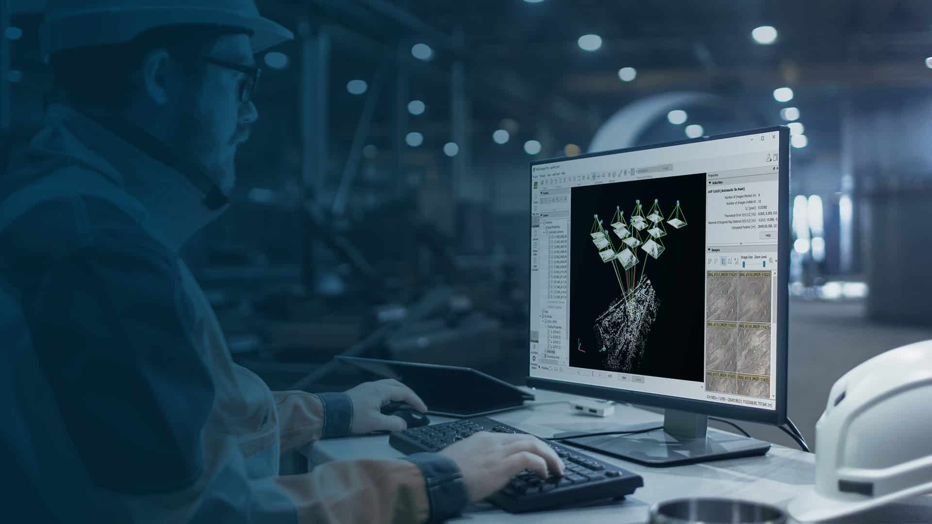
Pix4dmapper
Pix4Dmapper is the leading software for aerial photogrammetry. It converts your images into georeferenced 2D maps and highly accurate 3D models.

MAIN RESULTS
3D point cloud
Digital surface models
Orthomosaic
Volume calculation
Measurement
Contour levels
3D model with texture
Vegetative indices
SCAN EVERYTHING AROUND YOU
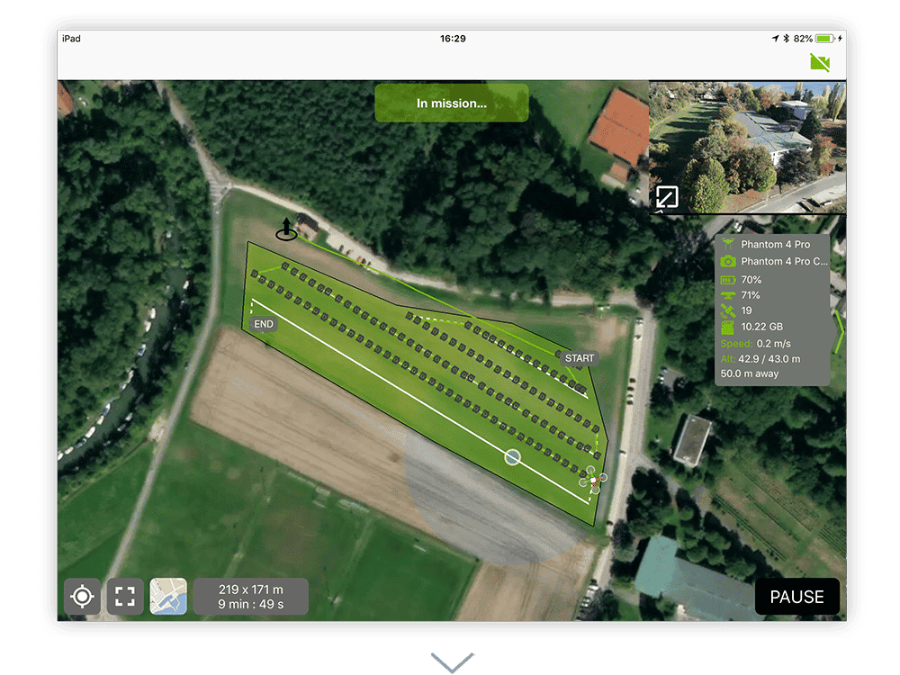
This software allows you to automate drone flight and data transfer and provides results with centimetre-level accuracies. If your project is relatively simple, standard models allow easy and automated processing of photogrammetric point clouds. It is easy to measure area, distance, volume and elevation.


Capture
Capture RGB, thermal or multispectral images with any camera or drone and import them into PIX4Dmapper.
SCAN
PIX4Dmapper’s photogrammetry algorithms transform terrestrial or aerial imagery into digital maps and 3D models. Process projects on the desktop using the photogrammetry software.
Control
Use the power of photogrammetry in the rayCloud environment to assess, control and improve project quality. Use the quality report to review generated results, calibration details and many other project quality indicators.
MEASUREMENT AND INSPECTION
Accurately measure distances, areas and volumes.
Pix4dsurvey
Bridging the gap between photogrammetry and CAD.

MAIN RESULTS
Extract only the most relevant information to streamline and simplify your research workflows.
- Vectorize anything
- Time savings
- CAD-ready
- Volume measurements

Capture
Capture images or point clouds with a drone or any laser scanner.
When using a drone, automate and optimize your flights with the free PIX4Dcapture mobile app.
Import
Import data from other Pix4D software or from a .las or .laz file into PIX4Dsurvey and combine multiple data sets in the same project. Work with image data and LiDAR point clouds.
CAD file ready for engineering
Vectorize
Generate a TIN for soil modeling and create engineering-ready vector CAD files from point cloud data by extracting key elements from your project with PIX4Dsurvey.
Model
Go from a lightweight point cloud to a model of your terrain. Use Smart Grid, TIN, and terrain classification to get accurate, actionable results.
Integrate
Open your simplified and accurate data in any CAD or GIS software with custom layers and properties that fit your current workflow.
Industry-specific applications

PIX4DFIELDS
Advanced agricultural mapping software for aerial crop analysis and digital agriculture.
- Results in the field – Quickly create maps (without needing the internet) to make decisions and act faster, without leaving the field.
-
Accurate maps – obtain maps of your fields and crops at any stage using satellite and/or drone imagery.
-
Reliable results— take the guesswork out of analyzing crop health maps and measuring issues using calibrated multispectral or full-resolution RGB imagery.
-
Easy to share – share data via PIX4Dcloud, as a PDF report, and in industry-standard formats.

PIX4DREACT
Rapid 2D mapping for emergency response and public safety.
- Speed – PIX4Dreact creates 2D maps from aerial images in minutes. Because when every second counts, up-to-date and reliable information is vital for teams on the ground.
-
Easy to use – Simple and intuitive to use, even in complex and stressful situations. PIX4Dreact has been developed with public safety and humanitarian aid professionals to address their specific challenges.
-
Lightweight and robust—light enough to work in the field with a mid-range computer. PIX4Dreact does not rely on an internet connection or the cloud for processing.
- Share results – PIX4Dreact results can be uploaded to PIX4Dcloud for sharing. Export your maps and reports and send them directly to your colleagues or teams in the field.

PIX4DCLOUD
The online platform for terrestrial and drone mapping, progress tracking, and construction documentation.
- Accurate results — trust Pix4D’s processing algorithms to deliver the search-level results you expect. Choose the AutoGCPs feature for even greater accuracy.
-
Simple analysis — get an instant view of any job from anywhere, in your browser, in 2D and 3D, with results you can measure, explore, compare, share, and collaborate on.
-
Up-to-date documentation – Maintain a permanent, up-to-date record of the project and resolve disputes effectively.

PIX4DENGINE
Build the future of digitized reality with our fully customizable photogrammetric reconstruction engine.
- Seamless integration—choose from our library of programming modules, ready to integrate into any business system via API or SDK.
-
On-premises or in the cloud – PIX4Dengine runs on your infrastructure or in our secure cloud, developed by AWS.
-
Customize and automate – Customize PIX4Dengine to automate even the most complex reality capture workflows.
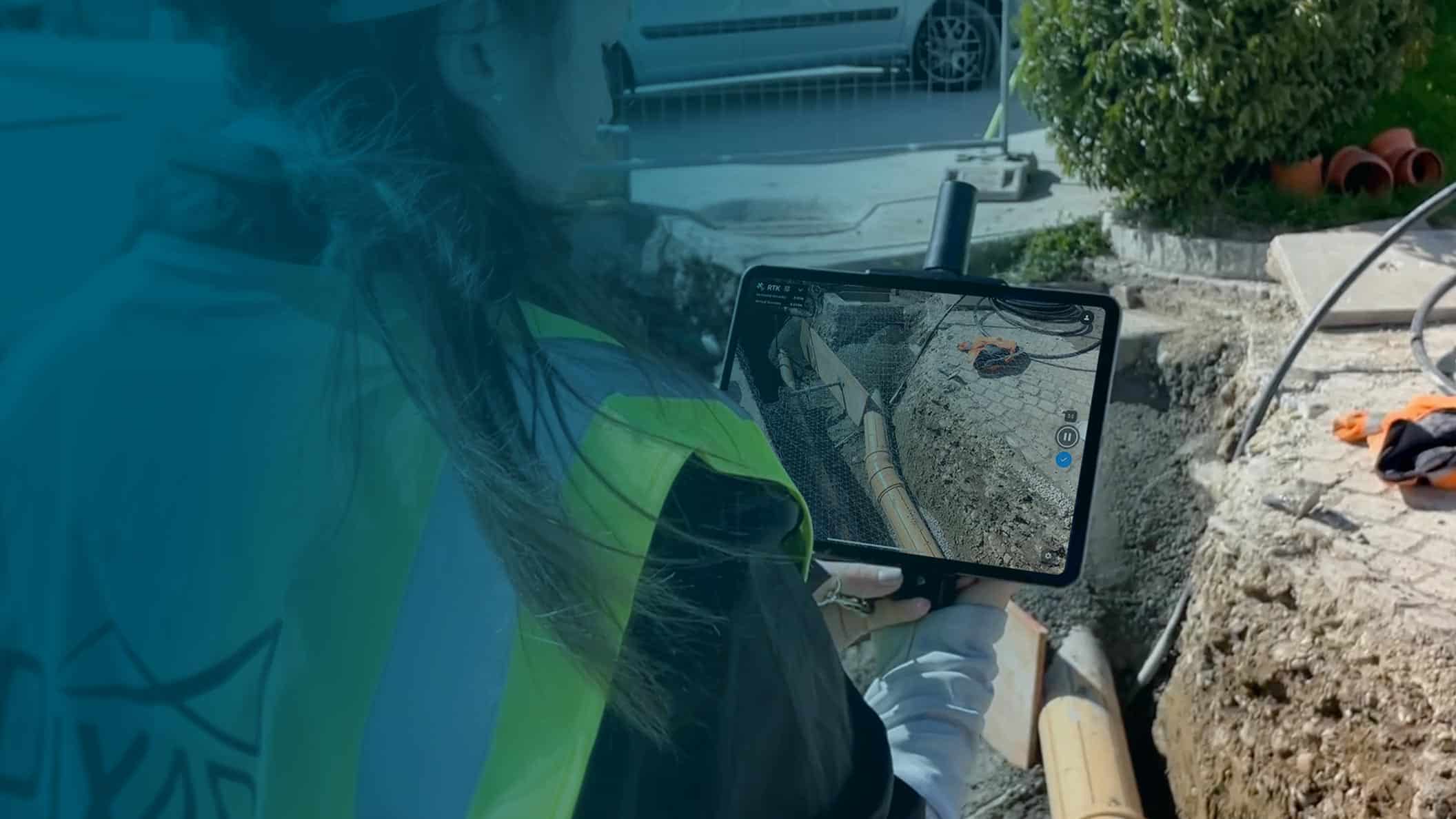
viDoc rtk rover
- Several options for accurately measuring points
- Measure obstructed points
- Accurate and reliable measurement methods
Measure with a laser, photogrammetry, or attach it to a surveying rod.
Complete the data collection without omitting anything that may be obstructed by objects such as trees or protrusions.
Take your measurements and reduce risk: cut down on unnecessary visits to trenches, etc. Make data collection safer.

-
The future of spot measurement with 3D scanning.
-
Use a portable RTK rover to elevate single-point measurement with 3D scanning.
-
For select iPhone and Android devices.
The viDoc RTK rover with PIX4Dcatch:
Precise search with a mobile device.
- Simple workflows from the field to the finish.
- RTK positioning rover for 3D scanning.
- Improved mobile data collection.
- Replacement of complex workflows.
- A complete and accurate workflow at your fingertips.
- Intuitive feel and structure.

